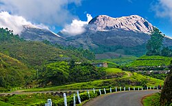
Friday, May 6, 2011

Kerala


Keralam
—  State  —
Kerala  or Keralam (Malayalam: കേരളം, Kēraḷam) is an Indian state, located south most on its west coast. It was created on 1 November 1956, by theStates Reorganisation Act, combining various Malayalam speaking regions.
The state has an area of 38,863 km2 (15,005 sq mi) and is bordered by Karnataka to the north and northeast, Tamil Nadu to the south and southeast and the Arabian Sea towards the west. Thiruvananthapuram is the capital city. Kochi and Kozhikode are other major cities. Kerala is also known for its many small towns that are scattered across the state, thus creating a higher density of population.
Stone age carving in Edakkal Caves had pictorial writings believed to be dating to at least 5000 BC, from the Neolithic man, indicating the presence of a prehistoric civilization or settlement in this region. From as early as 3000 BC, Kerala had established itself as a major spice trade center. Kerala had direct contact across the Arabian Sea with all the major Red Sea ports and the Mediterranean ports as well as extending to ports in the Far East. The spice trade between Kerala and much of the world was one of the main drivers of the world economy. For much of history, ports in Kerala were the busiest (Muziris) among all trade and travel routes in the history of the world.
During the classical Sangam period the region was ruled by the Chera Dynasty, which traded with the Greeks, Romans and Arabs. The Tamil Chera dynasty, Aysand the Pandyan Empire were the traditional rulers of Kerala whose patriarchal dynasties ruled until the 14th century. The Cheras collapsed after repeated attacks from the neighboring Chola Empire and Rashtrakuta Empire. Feudal Namboothiri Brahmin and Nair city-states subsequently gained control of the region.
Contact with Europeans after the arrival of the Portuguese explorer Vasco Da Gama in 1498 gave way to struggles between colonial and native interests. In 1795, the area was under the control of the British East India Company. From 1858, the power was shifted from the Company to the British, with the area being under the British Raj. After independence in 1947, the state of Kerala was created in 1956 from the former state of Travancore-Cochin, the Malabar district of the Madras State, and the Kasaragod taluk of Dakshina Kannada.
Kerala is a popular tourist destination famous for its backwaters, Ayurvedic treatments and tropical greenery. Kerala has a higher Human Development Index than all other states in India. The state has a literacy rate of 94.59 percent, the highest in India. A survey conducted in 2005 by Transparency International ranked Kerala as the least corrupt state in the country. Kerala has witnessed significant migration of its people, especially to the Persian Gulf countries during the Kerala Gulf boom, and is heavily dependent on remittances from its large Malayali expatriate community.

Etymology

Natives of Kerala, known as Malayalis, refer to their land as Keralam. Scholars agree, that Kerala is the word of the Classical Tamil Cheralam ("Land of theCheras") or chera-alam ("declivity of a hill or a mountain slope/range"). The country was anciently called Cheralam and Cherala Nadu. A 3rd-century-BC rock inscription by emperor Asoka the Great references Kerala as Keralaputra. Similarly, the Roman trade map Periplus Maris Erythraei references the Cheraterritory as Cerobothra.

History


Muniyara, dolmens erected by Neolithic tribesmen, in Marayur.
The spices from Malabar coast may have landed initially at Gulf of Aden and they eventually were transported to the East African trading ports in and around the city known in Grecian-Roman literature as Rhapta. Merchants then moved the commodities northward along the coast. In Roman times, they traveled to Muza in Yemen and finally to Berenice in Egypt. From Egypt they made their way to all the markets of Europe and West Asia.
The beginning of the trade is hinted at in Egyptian hieroglyphic inscriptions during the New Kingdom period about 3,600 years ago. The Pharaohs of Egypt opened up special relationships with the kingdom of Punt to the south. Although the Egyptians knew of Punt long before this period, it was during the New Kingdom that we really start hearing of important trade missions to that country that included large cargoes of spices. Particularly noteworthy are the marvelous reliefs depicting the trade mission of Queen Hatshepsut of the 18th Dynasty.
Findings of the earliest times of Kerala include Dolmens from the Marayur town area, which belong to the Neolithic period, dating back 10.000 years. Rockpainting was also prevalent during these ages. The most famous ones were found in the Edakkal Caves in Wayanad. These carvings date back to the early Stone Age period of 5000 B.C. A more recent finding is an Indus script symbol, which appears also in the Bronze Age Indus Valley Civilization. The prominent Indus script expert Iravatham Mahadevan said, that these findings were very significant and he called it a "major discovery". A cave near the Edakkal Caves in Thovarimala Ezhuthupara, Wayanad district, known locally as "Ezhuthupara" also carries pre-historic carvings dating back many millennia.
Kerala finds mention in the annals of international trade from as early as 3000 BC, having established itself as the major spice trade centre of the world and traded with Sumer. Kerala and Tamil Nadu once shared a common language and culture; this common area was known as Tamilakam.
Political map of Kerala and Tamil Nadu during the Sangam period at ca. 210 BCE
St. Thomas Church (Palayur) is one of the oldest churches in India
Dutch commander De Lannoysurrenders to Marthanda Varma at theBattle of Colachel. Depiction atPadmanabhapuram Palace
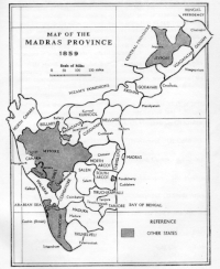
A nineteenth-century map of Madras Province in British India. After independence,Kerala was formed by merging Malabar, Cochin, Travancoreand the South Kanara district
During the 1st century BC the region was ruled by the Chera Dynasty established by the Dravidian tribe Villavar, whose mother tongue and court language was the ancient Tamil. The capital of Cheras was Vanchi. The southern Kerala was ruled by the Pandyan Kingdom with their capital at Nelcynda. The merchants from China, West Asia and Roman Empire had trade links with Cheras. The Sangam literature from the period has descriptions of the Roman ships coming to Muziris, laden with gold as exchange for pepper. Kerala is represented as the eastern tip of the known world in Tabula Peutingeriana, the only known surviving map of the Roman cursus publicus. The west Asian-semitic  Jewish, Christian, and Muslim immigrants established Juda Mappila, Nasrani Mappila, and Muslim Jonakan Mappila communities. The Jews first arrived in Kerala in 573 BC. The works of scholars and Eastern Christian writings state that Thomas the Apostle visited Muziris in Kerala in 52 CE to proselytize amongst Kerala's Jewish settlements and convert them to Christianity. However, the exact year of his arrival is disputed. Muslim merchants led by Malik ibn Dinar settled in Kerala by the 8th century CE and introduced Islam.
The Later Chera Kingdomwas returned to power (c. 800–1102) with the help of Arab spice Merchants, also called the Kulasekhara dynasty, was founded by Kulasekhara Varman who was also a Vaishnavaite saint. Ay kings ruled southern Kerala, but by the 10th century the Ay kingdom declined and became a part of the Chera Kingdom. A Keralite identity, distinct from the Tamils became linguistically separate during this period. The Kulasekhara dynasty came to an end by twelfth century, weakened due to the invasions by Pandyas and Cholas. In the absence of a strong central power, the state became divided under small principalities governed by Nair Cheftains. The kingdoms of Kochi, Venad, Kolathiri and Kozhikode Samuthiri emerged powerful.


The Colonial Era

After Vasco Da Gama's arrival in Kappad Kozhikode in 1498, the Portuguese began to gain control of the lucrative pepper trade which was revived in the Thirteen century AD to some extend. On 25 March 1505, Francisco de Almeida was appointed the Viceroy of India with his headquarters at Kochi. The period from 1500 to 1571 saw constant battles by the Saamoothiri and his navarch Kunjali Marakkar against the Portuguese until the latter were defeated and their fort destroyed by the Zamorin's forces at Chaliyam. The fall of Chaliyam fort marked the beginning of the end for the Portuguese in the great game of the East. Elsewhere, the Portuguese had established forts at Kannur, Cochin and Kollam.
The Dutch East India Company like the Portuguese before them took advantage of the conflicts between Kozhikode and Kochi and ousted the Portuguese to gain control of the trade. However, the Dutch were weakened by constant battles with Marthanda Varma of the Travancore Royal Family, the most prominent of them theBattle of Colachel in 1741. The Dutch finally surrendered to the British on 20 Oct 1795 when the latter marched from Calicut as part of the larger Napoleonic Warsbetween Holland and England in Europe. In 1766, Hyder Ali, the ruler of Mysore invaded northern Kerala. In the late 18th century, Tipu Sultan, Ali’s son and successor, launched campaigns against the expanding British East India Company, resulting in two of the four Anglo-Mysore Wars. He ultimately ceded Malabar District and South Kanara to the Company in the 1790s. The Company forged tributary alliances with Kochi in 1791 and Travancore in 1795. Malabar and South Kanara became part of the Madras Presidency.
The major revolts that occurred before independence were the 1946 Punnapra-Vayalar uprising in Travancore and the 1921 Malabar Rebellion in Malabar which was under British rule. The Dewan of Travancore Velayudan Thampi Dalava, and Pazhassi Raja in Malabar, among others, vied for greater autonomy or independence. Many actions, spurred by such leaders as Vaikunda Swami, Sree Narayana Guru and Chattampi Swamikal, instead protested such conditions as untouchability; notable was the 1924 Vaikom Satyagraham, which resulted, Chitra Thirunal Bala Rama Varma of Travancore issuing in 1936, the Temple Entry Proclamation that opened Hindu temples to all castes; Malabar soon did likewise. But Cochin did not do the Temple entry proclamation (1948) until after India's independence. The 1921 Moplah Rebellion involved Mappila Muslims rioting against Hindu zamindars Zamindari system and the British Raj.


Post Independence

After India gained her independence in 1947, Travancore and Cochin were merged to form Travancore-Cochin on 1 July 1949. On 1 January 1950 (Republic Day), Travancore-Cochin was recognised as a state. The Madras Presidency was organised to form Madras State in 1947.


Formation of the State of Kerala and beyond

On 1 November 1956, the state of Kerala was formed by the States Reorganisation Act merging the Malabar district, Travancore-Cochin (excluding four southern taluks, which were merged with Tamil Nadu), and the taluk of Kasargod, South Kanara. Elections for the new Kerala Legislative Assembly were held in 1957; this resulted in the formation of a communist-led government headed by E.M.S. Namboodiripad. Radical reforms introduced by the E. M. S. Namboodiripad's government in favour of farmers and labourers helped change, to a great extent, the iniquitous social order that had prevailed in the land for a long time.
To International sensations, the Communist government in 2006 banned the production and sale of Coca Cola and Pepsi after large amounts of pesticides were found in the drinks, later the decision was lifted by a court in the same year.International Herald Tribune: Indian state lifts cola ban In addition, the Government once openly said to the distribution of free software and against Microsoft whom they referred as a monopolist.


References in Hinduism

The Matsya Purana mentions the Malaya Mountains in Kerala as the setting for the story of the Matsya Avatara of Lord Vishnu and King Manu (King Satyavrata).The Vamana Purana also mentions King Mahabali as the righteous and virtuous ruler that has his capital in Kerala. Kerala has been referenced in puranas as created by Parashurama by throwing his axe into the sea. The Aitareya Aranyaka is the earliest Sanskrit work that specifically mentions Kerala.

Geography and climate


Munnar hill station, Kerala
Kerala is wedged between the Lakshadweep sea and the Western Ghats. Lying between north latitudes 8°18' and 12°48' and east longitudes 74°52' and 77°22', Kerala experiences the humid equatorial tropic climate. The state has a coast of length 590 km (367 mi) and the width of the state varies between 35 and 120 km (22–75 miles). Geographically, Kerala can be divided into three climatically distinct regions: the eastern highlands (rugged and cool mountainous terrain), the central midlands (rolling hills), and the western lowlands (coastal plains). Located at the extreme southern tip of the Indian subcontinent, Kerala lies near the centre of the Indian tectonic plate; hence, most of the state is subject to comparatively little seismic and volcanic activity. Pre-Cambrian and Pleistocene geological formations compose the bulk of Kerala’s terrain.
The eastern Kerala region consists of high mountains, gorges and deep-cut valleys immediately west of the Western Ghats' rain shadow. Forty-one of Kerala’s west-flowing rivers, and three of its east-flowing ones originate in this region. The Western Ghats form a wall of mountains interrupted only near Palakkad, where the Palakkad Gap breaks through to provide access to the rest of India. The Western Ghats rises on average to 1,500 m (4920 ft) above sea level, while the highest peaks may reach to 2,500 m (8200 ft). Anamudi is the highest peak at an elevation of 2,695 metres (8,130 ft). Just west of the mountains lie the midland plains comprising central Kerala, dominated by rolling hills and valleys. Generally ranging between elevations of 250–1,000 m (820–3300 ft), the eastern portions of the Nilgiri and Palni Hills include such formations as Agastya Mala and Anamala.
Kerala’s western coastal belt is relatively flat, and is criss-crossed by a network of interconnected brackish canals, lakes, estuaries, and rivers known as the Kerala Backwaters. Lake Vembanad—Kerala’s largest body of water dominates the Backwaters; it lies between Alappuzha and Kochi and is more than 200 km² in area. Around 8% of India's waterways (measured by length) are found in Kerala. The most important of Kerala’s forty-four rivers include the Periyar (244 km), the Bharathapuzha (209 km), the Pamba (176 km), the Chaliyar (169 km), the Kadalundipuzha River(130 km), the Valapattanam (129 km) and the Achankovil (128 km). The average length of the rivers of Kerala is 64 km. Many of the rivers are small and entirely fed by monsoon rains. These conditions result in the nearly year-round water logging of such western regions as Kuttanad, 500 km² of which lies below sea level. As Kerala's rivers are small and lack deltas, they are more prone to environmental factors. The rivers also face problems such as sand mining and pollution. The state experiences several natural hazards such as landslides, floods, lightning and droughts. The state was also affected by the 2004 Indian Ocean Tsunami.
A catastrophic flood occurred in Kerala in 1341 AD that drastically modified the terrain and consequently affected the history. The flood resulted in changing the course of the river Periyar, recession of Arabian Sea by several miles downwards making the Kuttanad region cultivable, closure of the Muziris (Kodungalloor) harbour and creation of a new harbour at Kochi.
With 120–140 rainy days per year, Kerala has a wet and maritime tropical climate influenced by the seasonal heavy rains of the southwest summer monsoon. In eastern Kerala, a drier tropical wet and dry climate prevails. Kerala's rainfall averages 3,107 mm annually. Some of Kerala's drier lowland regions average only 1,250 mm; the mountains of eastern Idukki district receive more than 5,000 mm of orographic precipitation, the highest in the state.
During summer, Kerala is prone to gale force winds, storm surges, cyclone-related torrential downpours, occasional droughts, and rises in sea level. The mean daily temperatures range from 19.8 °C to 36.7 °C. Mean annual temperatures range from 25.0–27.5 °C in the coastal lowlands to 20.0–22.5 °C in the eastern highlands.

Flora and fauna


Haliastur indus in Kerala
A blue tiger (Tirumala limniace) butterfly in Chalakudy
Petals of the gloriosa lily (Gloriosa superba) flower curve upward into a claw-like shape; below, its stamens grow radially outwards.
A fulvous forest skimmer(Neurothemis fulvia) in Chalakudy, nearThrissur
Population density map of Kerala graded from darkest shading (most dense) to lightest (least dense)
The Kerala Legislative Assembly Building in Thiruvananthapuram
Much of Kerala's notable biodiversity is concentrated and protected in the Western Ghats. Almost a fourth of India's 10,000 plant species are found in the state. Among the almost 4,000 flowering plant species (1,272 of which are endemic to Kerala and 159 threatened) are 900 species of medicinal plants.
Its 9,400 km² of forests include tropical wet evergreen and semi-evergreen forests (lower and middle elevations—3,470 km²), tropical moist and dry deciduous forests (mid-elevations—4,100 km² and 100 km², respectively), and montane subtropical and temperate (shola) forests (highest elevations—100 km²). Altogether, 24% of Kerala is forested. Two of the world’s Ramsar Convention listed wetlands—Lake Sasthamkotta and the Vembanad-Kol wetlands—are in Kerala, as well as 1455.4 km² of the vast Nilgiri Biosphere Reserve. Subjected to extensive clearing for cultivation in the 20th century, much of the remaining forest cover is now protected from clearfelling. Kerala's fauna are notable for their diversity and high rates of endemism: 102 species of mammals (56 of which are endemic), 453 species of birds, 202 species of freshwater fishes, 169 species of reptiles (139 of them endemic), and 89 species of amphibians (86 endemic).These are threatened by extensive habitat destruction, including soil erosion, landslides, salinization, and resource extraction.
Eastern Kerala’s windward mountains shelter tropical moist forests and tropical dry forests, which are common in the Western Ghats. Here, sonokeling (Dalbergia latifolia),anjilimullumurikku (Erythrina), and Cassia number among the more than 1,000 species of trees in Kerala. Other plants include bamboo, wild black pepper, wild cardamom, the calamus rattan palm (a type of climbing palm), and aromatic vetiver grass (Vetiveria zizanioides). Living among them are such fauna as Indian Elephant (Elephas maximus indicus), Bengal Tiger, Indian Leopard (Panthera pardus fusca), Nilgiri Tahr, Common Palm Civet, and Grizzled Giant Squirrel  Reptiles include the King Cobra (Ophiophagus hannah), viper, python, and Mugger Crocodile (Crocodylus palustris) . Kerala's birds are legion—Malabar Trogon, the Great Hornbill, Kerala Laughingthrush, Darter, and Southern Hill Myna are several emblematic species. In lakes, wetlands, and waterways, fish such as kadu (stinging catfish) and Choottachi(Orange chromide—Etroplus maculatus) are found.

Subdivisions


Kerala's fourteen districts are distributed among Kerala's six historical regions: North Malabar (Far-north Kerala), Malabar (northern Kerala), Kochi (central Kerala), Northern Travancore, Central Travancore (southern Kerala) and Southern Travancore (Far-south Kerala). Kerala's modern-day districts (listed in order from north to south) correspond to them as follows:
  • North Malabar: Kasaragod, Kannur, Mananthavady Taluk of Wayanad, Koyilandy and Vadakara Taluks of Kozhikode
  • Malabar: Wayanad except Mananthavady Taluk, Kozhikode except Vadakara and Koyilandy Taluks, Malappuram, Palakkad District except Chittur Taluk and a part of Thrissur
  • Kochi: A part of Ernakulam, Chittur Taluk of Palakkad, and a part of Thrissur.
  • Northern Travancore: Part of Ernakulam, and Idukki.
  • Central Travancore: Southern part of Idukki, Kottayam, Alappuzha, Pathanamthitta and northern part of Kollam.
  • Southern Travancore: Southern part of Kollam, Thiruvananthapuram.
(traditionally, Nanchinad in Kanyakumary, which is part of Tamil Nadu now)
Kerala's 14 districts, which serve as the administrative regions for taxation purposes, are further subdivided into 63 taluks; these have fiscal and administrative powers over settlements within their borders, including maintenance of local land records.Taluks of kerala are further divided into 1453 revenue villages and 1007 Gram panchayats.
Mahé, a part of the Indian union territory of Puducherry (Pondicherry), is a coastal exclave surrounded by Kerala on all of its landward approaches.

Destinations of Kerala

Main tourist destinations of Kerala include Alappuzha, Bekal, Bharananganam, Guruvayur, Idukki, Kannur, Kochi, Kottayam, Kovalam, Kozhikode, Kumarakom, Malayattoor,Munnar, Parumala, Peermade, Sabarimala, Thekkady, Thiruvananthapuram, Thrissur, Varkala Wayanad and Sasthamkotta

Government


Government of Kerala is setup according to rules and regulations by Government of India. State is governed via a parliamentary system of representative democracy; universal suffrage is granted to state residents. There are three branches of government. The unicameral legislature, the Kerala Legislative Assembly, comprises elected members and special office bearers (the Speaker and Deputy Speaker) elected by the members from among themselves. Assembly meetings are presided over by the Speaker and in the Speaker's absence, by the Deputy Speaker. Kerala has 140 Assembly constituencies. The state sends 20 members to the Lok Sabha and 9 to the Rajya Sabha, the Indian Parliament's upper house.
The Governor of Kerala is the constitutional head of state, and is appointed by the President of India. The executive authority is headed by the Chief Minister of Kerala, who is the de facto head of state and is vested with extensive executive powers; the Legislative Assembly's majority party leader is appointed to this position by the Governor. The Council of Ministers, which answers to the Legislative Assembly, has its members appointed by the Governor on advice of the Chief Minister. Auxiliary authorities known as panchayats, for which local body elections are regularly held, govern local affairs.
The judiciary comprises the Kerala High Court (Located at Ernakulam has a Chief Justice combined with 26 permanent and two additional (pro tempore) justices) as the apex court in the state and a system of lower courts. Kerala High Court also hears cases from the Union Territory of Lakshadweep.
The state's 2005–2006 budget was 219 billion INR. The state government's tax revenues (excluding the shares from Union tax pool) amounted to 111,248 million INR in 2005, up from 63,599 million in 2000. Its non-tax revenues (excluding the shares from Union tax pool) of the Government of Kerala as assessed by the Indian Finance Commissions reached 10,809 million INR in 2005, nearly double the 6,847 million INR revenues of 2000. However, Kerala's high ratio of taxation to gross state domestic product (GSDP) has not alleviated chronic budget deficits and unsustainable levels of government debt, impacting social services.
Kerala hosts two major political alliances: the United Democratic Front (UDF—led by the Indian National Congress)and the Left Democratic Front (LDF—led by theCommunist Party of India (Marxist) (CPI(M)). At present, the LDF is the ruling coalition in government; V.S. Achuthanandan of the CPI(M) is the Chief Minister of Kerala andOommen Chandy of the UDF is the Chief Opposition leader. Strikes, protests and marches are ubiquitous in Kerala due to the comparatively strong presence of labour unions.

Economy


Since independence, Kerala was managed as a democratic socialist welfare economy. Since the 1990s, liberalisation of the mixed economy allowed onerous Licence Raj restrictions against capitalism and foreign direct investment to be lightened, leading to economic expansion and job creation. In fiscal year 2007-2008, nominal gross state domestic product (GSDP) was Indian Rupee ₹162,414.79 crore (US$36.06 billion). Recent GSDP growth (9.2% in 2004–2005 and 7.4% in 2003–2004) has been robust compared to historical averages (2.3% annually in the 1980s and between 5.1% and 5.99% in the 1990s). The state clocked 8.93% growth in enterprises from 1998 to 2005 compared with 4.80% nationally. Relatively few such enterprises are major corporations or manufacturers.Kerala's Human Development Index rating is the highest in India. This apparently paradoxical "Kerala phenomenon" or "Kerala model of development" of high human and low economic development results from the strong service sector. Kerala's economy depends on emigrants working in foreign countries (mainly in the Persian Gulf countries such as United Arab Emirates or Saudi Arabia) and remittances annually contribute more than a fifth of GSDP. As of 2008, the Gulf countries altogether have a Keralite population of more than 2.5 million, who send home annually a sum of USD 6.81 billion, which is more than 15.13% of Remittance to India in 2008.
A building in the Infosys-Thiruvananthapuram campus
Rural women processing coir threads
The service sector (including tourism, public administration, banking and finance, transportation, and communications—63.8% of GSDP in 2002–2003) and the agricultural and fishing industries (together 17.2% of GSDP) dominate the economy. Nearly half of Kerala's people are dependent on agriculture alone for income. Some 600 varieties of rice (Kerala's most important staple food and cereal crop) are harvested from 3105.21 km² (a decline from 5883.4 km² in 1990) of paddy fields; 688,859 tonnes are produced per annum. Other key crops include coconut (899,198 ha), tea, coffee (23% of Indian production, or 57,000 tonnes), rubber, cashews, and spices—including pepper, cardamom, vanilla, cinnamon, and nutmeg. Around 1.050 million fishermen haul an annual catch of 668,000 tonnes (1999–2000 estimate); 222 fishing villages are strung along the 590 km coast. Another 113 fishing villages dot the hinterland.
Traditional industries manufacturing such items as coir, handlooms, and handicrafts employ around one million people. Around 180,000 small-scale industries employ around 909,859 Keralites; 511 medium and large scale manufacturing firms are located in Kerala. A small mining sector (0.3% of GSDP) involves extraction of ilmenite, kaolin,bauxite, silica, quartz, rutile, zircon, and sillimanite. Home gardens and animal husbandry also provide work for hundreds of thousands of people. Other major sectors are tourism, manufacturing, and business process outsourcing. As of March 2002, Kerala's banking sector comprised 3341 local branches; each branch served 10,000 persons, lower than the national average of 16,000; the state has the third-highest bank penetration among Indian states. Unemployment in 2007 was estimated at 9.4%; underemployment, low employability of youths, and a 13.5% female participation rate are chronic issues. Poverty rate figures range from 12.71% to as high as 36%. More than 45,000 residents live in slum conditions.
The state treasury has suffered loss of thousands of millions of rupees thanks to the state staging over 100 hartals annually in recent times. A record total of 223 hartals were observed in 2006, resulting in a revenue loss of over Indian Rupee ₹2000 crore.
Vikram Sarabhai Space Centre (VSSC), a major space research centre of the Indian Space Research Organisation (ISRO) is located in Thiruvananthapuram. A second missile making unit of BrahMos Aerospace Private Limited named BrahMos Aerospace Thiruvananthapuram Ltd is also in Thiruvananthapuram, Kerala.

Transport


Trivandrum Central Railway Station Building
State Water Transport Department is the main agency who provides inland water transport facilities to the people residing in the water logged areas.
A road in Kerala


Roads in Kerala

Kerala has 145,704 kilometers (90,536 mi) of roads (4.2% of India's total). This translates to about 4.62 kilometers (2.87 mi) of road per thousand population, compared to an all India average of 2.59 kilometers (1.61 mi). Virtually all of Kerala's villages are connected by road.
Roads in Kerala includes 1,524 km of National highway (2.6% of nation's total), 4006 km of state highway and 23,702 km of district roads. Most of Kerala's west coast is accessible through two national highways, NH 47, and NH 17 and eastern side is accessible through various State Highways. There is also a Hill Highway (Kerala) proposed, to make easy access to eastern hills.
NH 17 connects Edapally (Kochi) to Panavel (near Mumbai) and is the longest stretch of national highway through the state. The other major national highway passing through the state is National Highway 47 which connects Salem to Kanyakumari and passes through the major towns and cities like Palakkad, Thrissur, Kochi, Alappuzha, Kollam andThiruvananthapuram. The Salem-Kochi stretch of this highway is a part of North-South Corridor of the Indian highway system. The length of the National Highway 47 (India) through Kerala is 416.8 km. NH 49 (Kochi - Dhanushkodi), NH 208 (Kollam - Thirumangalam), NH 212 (Kozhikode - Mysore), NH 213 (Kozhikode - Palakkad), NH 220 (Kollam - theni) are the other national highways serving the state of Kerala.
The Kerala State Transport Project (KSTP), which includes the GIS-based Road Information and Management Project (RIMS), is responsible for maintaining and expanding the state highways system; it also oversees major district roads.
Traffic in Kerala has been growing at a rate of 10–11% every year, resulting in high traffic and pressure on the roads. Kerala's roaddensity is nearly four times the national average, reflecting the state's high population density. Kerala's annual total of road accidents is among the nation's highest.


Railway

The Indian Railways' Southern Railway line runs throughout the state, connecting all major towns and cities except those in the highland districts of Idukki and Wayanad. Trivandrum Railway Division and Palakkad Railway Division are the two railway divisions in the state. Kerala's major railway stations are Kasaragod, Kannur, Kozhikode, Shornur Junction, Palakkad Junction, Thrissur, Aluva,Ernakulam Town, Ernakulam Junction, Alappuzha, Kottayam, Chengannur, Kollam Junction, Kochuveli and Thiruvananthapuram Central.


Water ways

The backwaters traversing the state are an important mode of inland navigation. National Waterway 3 traverse through the state.


Airports

The state has three major international airports at Thiruvananthapuram, Kochi, and Kozhikode. The Trivandrum International Airport is the first International airport in a non-metro city in India. The Cochin International Airport (COK) was the first Indian airport incorporated as a public limited company and is funded by nearly 10,000 Non Resident Indians from 30 countries. A fourth international airport is proposed at Kannur.